Điện Biên Province
The glorious victory of five continents — Điện Biên Phủ and the westernmost point of the Fatherland
Northern Region · Northern Midlands and Mountainous Area · Northwest
The glorious victory of five continents — Điện Biên Phủ and the westernmost point of the Fatherland
Northern Region · Northern Midlands and Mountainous Area · Northwest
Điện Biên is one of 11 provinces that will not merge according to Resolution 202/2025/QH15, maintaining its administrative boundaries. With an area of 9,539.90 km² and a population of only 653,422 people, it is the province with the lowest population density in Vietnam (approximately 68 people/km²). Located in the far Northwest of the Fatherland, Điện Biên shares a border with Laos (414 km) and China (38 km). The province is world-renowned for the Điện Biên Phủ Victory on May 7, 1954 — 'glorious across five continents, shaking the world', ending 9 years of resistance against French colonialism. The westernmost point of the Fatherland is at A Pa Chải, Sín Thầu commune, Mường Nhé district — the meeting point of the borders of three countries: Vietnam, Laos, and China. The administrative center is in Điện Biên Phủ city.
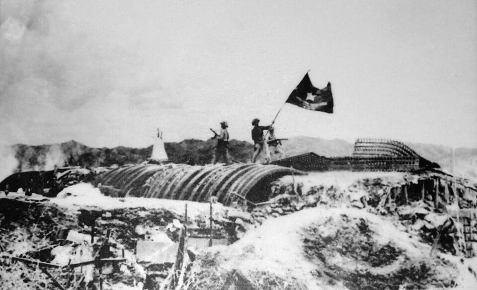
A1 Hill is located right in the center of Điện Biên Phủ city, about 32 m higher than the Mường Thanh field. This was one of the key defensive strongholds of the French army — dubbed the 'steel gate' protecting the Điện Biên Phủ entrenched camp. From March 30 to the night of May 6, 1954, Vietnamese soldiers launched four assaults on A1 Hill, a battle that lasted 39 days and nights — the fiercest in the entire 55-day and night campaign. On the night of May 6, a 960 kg explosive charge placed in a secret tunnel was detonated, opening the way for the final general offensive. The next day, May 7, 1954, the entire Điện Biên Phủ entrenched camp surrendered. Currently, the hill still has the explosion crater, the French command bunker, tank wreckage, and a monument to fallen soldiers — classified as a Special National Relic in 2009.
Things to do: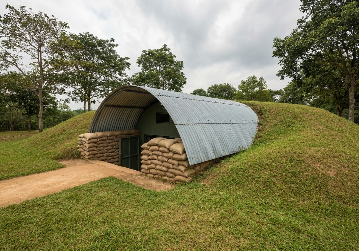
General De Castries' command bunker — Commander of the Điện Biên Phủ entrenched camp — is located in the center of the Mường Thanh subdivision, about 1.5 km from the Campaign Headquarters. The bunker was built with reinforced concrete 1 m thick, rectangular, 20 m long and 8 m wide, with multiple floors and working rooms, camouflaged with sandbags and burlap sacks. On the afternoon of May 7, 1954, soldiers of Company 360, Regiment 209, Division 312, led by Tạ Quốc Luật, stormed in and captured General De Castries and his entire command — a historic moment that ended 55 days and nights of the campaign and 9 years of resistance against the French. Currently, the bunker is preserved almost intact, and visitors can go inside to see the command rooms, desks, and battle maps.
Things to do: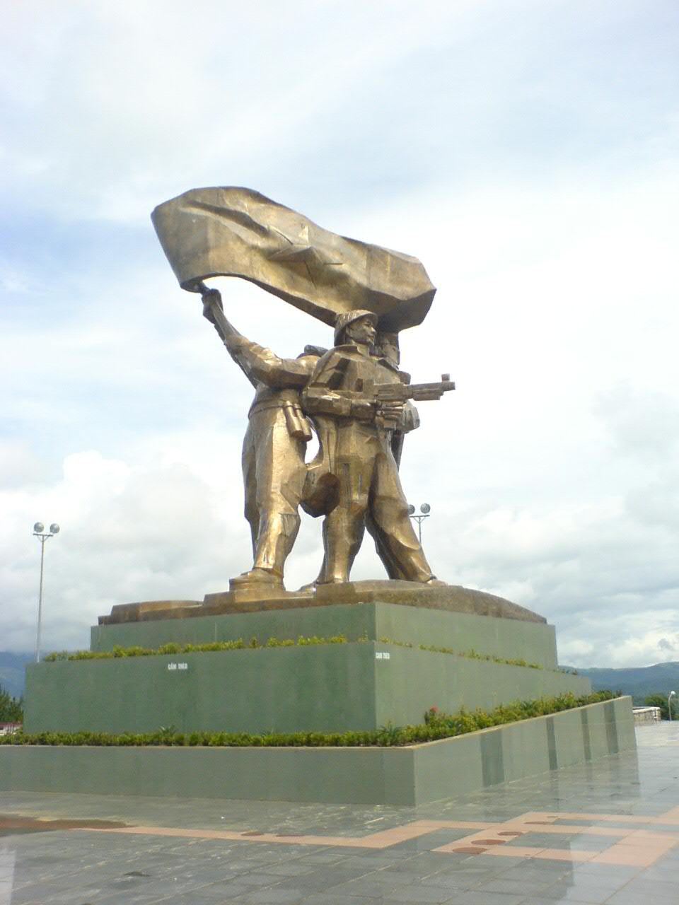
The Điện Biên Phủ Victory Monument is located on the top of D1 hill right in the center of Điện Biên Phủ city, inaugurated on April 30, 2004, on the occasion of the 50th anniversary of the victory. The monument is 16.6 m high, cast from pure bronze weighing 220 tons — one of the largest bronze monuments in Vietnam. The artwork depicts three liberation soldiers waving the 'Quyết chiến – Quyết thắng' (Determined to Fight – Determined to Win) victory flag and holding a Thái baby — symbolizing the solidarity between the army and the people. Visitors climb 320 stone steps to reach the hilltop, admire the panoramic view of Điện Biên Phủ city and the Mường Thanh field from above. In the evening, the monument is illuminated, creating an impressive landscape.
Things to do: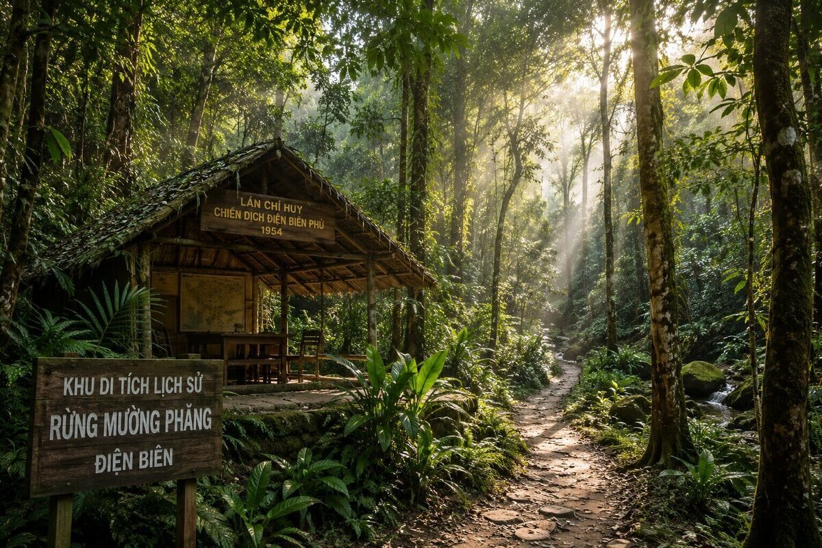
The Điện Biên Phủ Campaign Command Post is located in Mường Phăng commune, about 25 km east of Điện Biên Phủ city. This is the 'headquarters' where General Võ Nguyên Giáp and the Campaign Command worked and made historical decisions throughout the 105 days of the Điện Biên Phủ campaign (from January 31 to May 15, 1954). The Command Post was camouflaged in the primeval forest at the foot of the mountain, consisting of many small working huts — for the General, Chief of Staff Hoàng Văn Thái, Head of Operations Lê Trọng Tấn, the cryptology system, observation post… Most importantly, it was the hut where General Võ Nguyên Giáp made the historic decision to change the combat strategy from 'swift attack, swift victory' to 'steady attack, steady advance'. The old forest around it was voluntarily protected by the local people — now called 'General's forest', recognized as a Special National Relic in 2009.
Things to do:
Pá Khoang Lake is located in Pá Khoang commune, about 20 km northeast of Điện Biên Phủ city — on the route to Mường Phăng Command Post. It is an irrigation lake built to supply water to the Mường Thanh field, with its surface spreading out amidst the primeval forest, creating a rare peaceful landscape in the Northwest. The climate around the lake is cool all year round, earning it the nickname 'miniature Đà Lạt' of Điện Biên. Visitors can take a boat on the lake, walk in the forest, visit surrounding Thái ethnic villages, and stay in homestays. In spring, ban flowers bloom white across the entire area — the most beautiful time for Pá Khoang.
Things to do: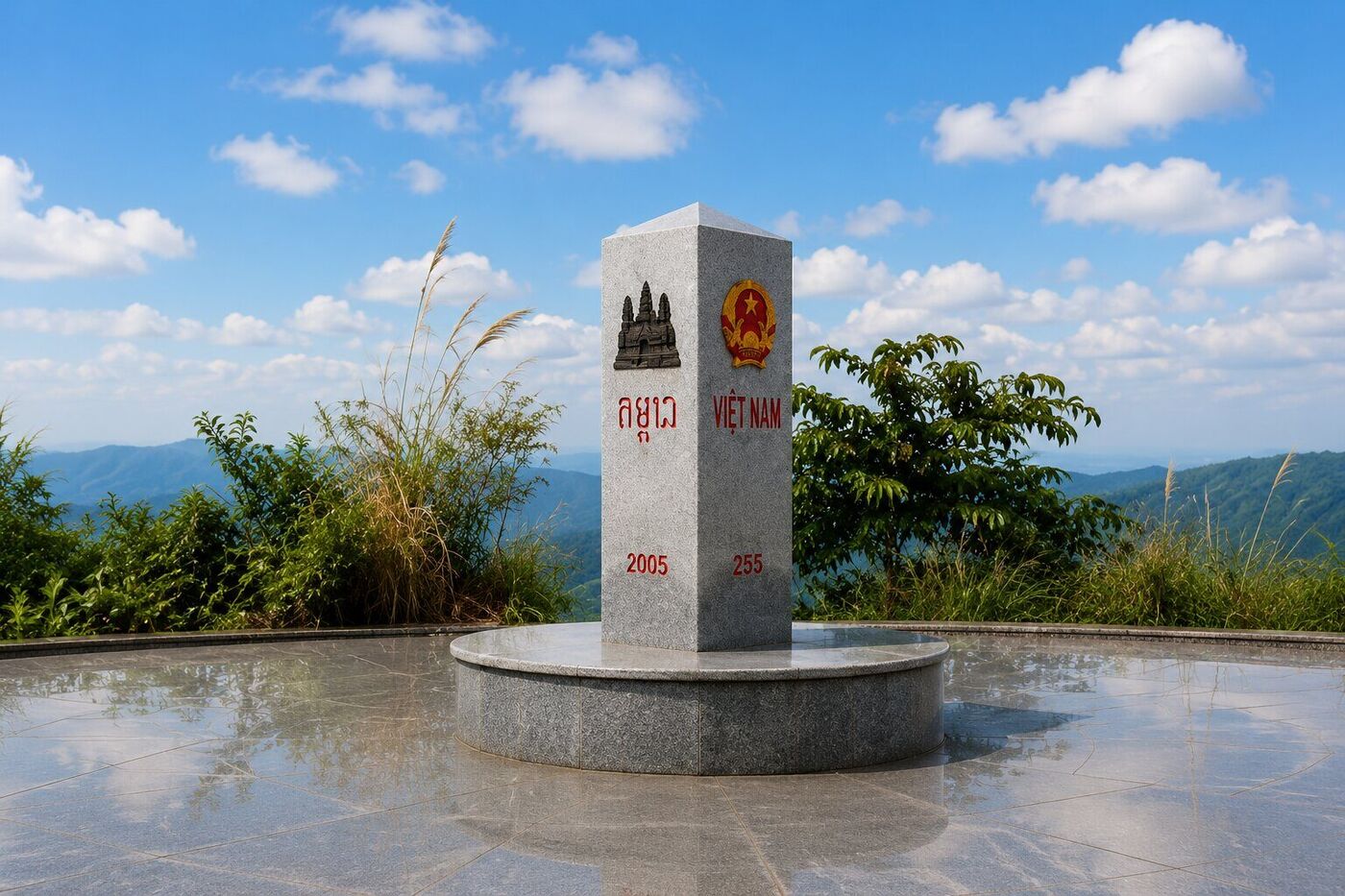
A Pa Chải, located in Sín Thầu commune, Mường Nhé district, is the westernmost point of the Fatherland — where the borders of Vietnam, Laos, and China meet. Border marker No. 0 (also known as the tri-border marker) is placed on the peak of Khoang La San mountain at an altitude of 1,864 m, completed in 2005 after the three countries demarcated and planted markers. The marker is a triangular granite pillar — each side engraved with the name of a country in text and its National Emblem. The journey to the marker takes about 4–5 hours of trekking from A Pa Chải border post, through dense primary forest with vines and steep slopes — only possible after obtaining permission from the Border Guard. A Pa Chải is one of Vietnam's 'Four Extremes' along with Lũng Cú (northernmost), Mũi Đôi (easternmost), and Mũi Cà Mau (southernmost) — a must-visit for backpackers conquering the entire country.
Things to do:No. Điện Biên is one of 11 provinces that will not undergo provincial-level reorganization according to Resolution 202/2025/QH15. It will retain its area of 9,539.90 km² and population of 653,422 people, with commune-level units streamlined to 45 according to Resolution 1661/NQ-UBTVQH15.
By road, it's about 490 km, taking 11–13 hours via National Route 6 and National Route 279. By air, there are daily direct flights from Hanoi to Điện Biên Phủ, taking about 1 hour — this is the most popular option.
May 7, 1954 — that afternoon, General De Castries surrendered, and the entire Điện Biên Phủ fortified complex collapsed. May 7 annually is Điện Biên Phủ Victory Day — a national holiday in Vietnam.
No. A Pa Chải is located in a border area — it is mandatory to obtain a permit at the A Pa Chải Border Guard Station and have a border guard guide you. Prepare your ID card/Citizen ID card and contact them in advance through your hotel or tour.
A standard 3-day, 2-night tour by plane: Day 1, fly to Điện Biên Phủ to visit A1 Hill, De Castries's Bunker, and the Monument; Day 2, go to Mường Phăng + Pá Khoang; Day 3, buy local specialties and fly back. A tour to conquer A Pa Chải requires an additional 2 days.
March is when the ban flowers bloom white across the Northwest — Điện Biên is most beautiful. May is the anniversary of the victory, attracting many pilgrims. September – November offers cool weather, making trekking to A Pa Chải easier.