
Lai Châu Province
The remote Northwest frontier — Ô Quý Hồ Pass and Phìn Hồ terraced fields
Northern Vietnam · Northwest
The remote Northwest frontier — Ô Quý Hồ Pass and Phìn Hồ terraced fields
Northern Vietnam · Northwest
Lai Châu is Vietnam's westernmost border province in the Northwest, bordering China via the Ma Lù Thàng border gate, maintaining its administrative boundaries according to Resolution 202/2025/QH15. With an area of 9,068.83 km² but a population of only 460,196 people, it is the province with the lowest population density in Vietnam — one of the most pristine and mysterious in the country. Lai Châu boasts majestic Northwest landscapes: Putaleng peak (3,049 m) — the second highest in Vietnam, Ô Quý Hồ Pass (2,073 m) — one of the 'four great passes' of the Northwest, Phìn Hồ – Sin Suối Hồ terraced fields, and Vàng Pheo hot spring. As home to 20 ethnic minority groups (Thái, H'Mông, Dao, Hà Nhì, Lự, Mảng, Si La — ethnic groups with fewer than 1,000 people), Lai Châu preserves the most authentic village culture of the Northwest. Lai Châu city is 450 km from Hanoi.
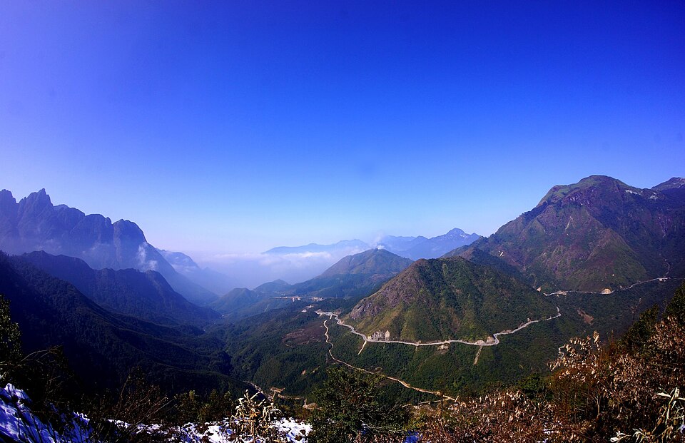
Đèo Ô Quý Hồ (đèo Hoàng Liên Sơn) is located on National Route 4D connecting Lai Châu – Sa Pa, with the pass summit at an altitude of 2,073 m — it is the highest and longest pass among the 'Four Great Passes' of the Northwest (along with Khau Phạ, Pha Đin, Mã Pí Lèng). The pass is about 50 km long, winding along the Hoàng Liên Sơn mountain range with views of deep valleys, clouds drifting across the road, and ancient rhododendron forests. At the pass summit is Cổng Trời — a famous check-in point, looking towards Lai Châu is the deep Phong Thổ valley, and towards Lào Cai is misty Sa Pa. Traveling through the pass in the early morning or late afternoon — when clouds roll and sunlight slants — is the ultimate Northwest backpacking experience. The pass is also the starting point for trekking Putaleng (3,049 m).
Things to do:
Phìn Hồ is a highland commune in Tam Đường district, 25 km from Lai Châu city — located on the western slope of the Hoàng Liên Sơn range opposite Sa Pa. The terraced fields here are layered from 1,000 m up to 1,800 m, stretching for tens of kilometers along the valley — as beautiful as Sa Pa but much more pristine, with almost no tourists. Nearby is Sin Suối Hồ village — a model H'Mông village famous for its community tourism model: clean village, flower-lined roads, opium eradication, tourism development. Sin Suối Hồ is located at 1,400 m, with cool climate, and thousands of square meters of cymbidium orchid gardens — most beautiful in January – March. Visitors can stay in homestays, eat H'Mông meals, and listen to stories about the village's journey of transformation.
Things to do: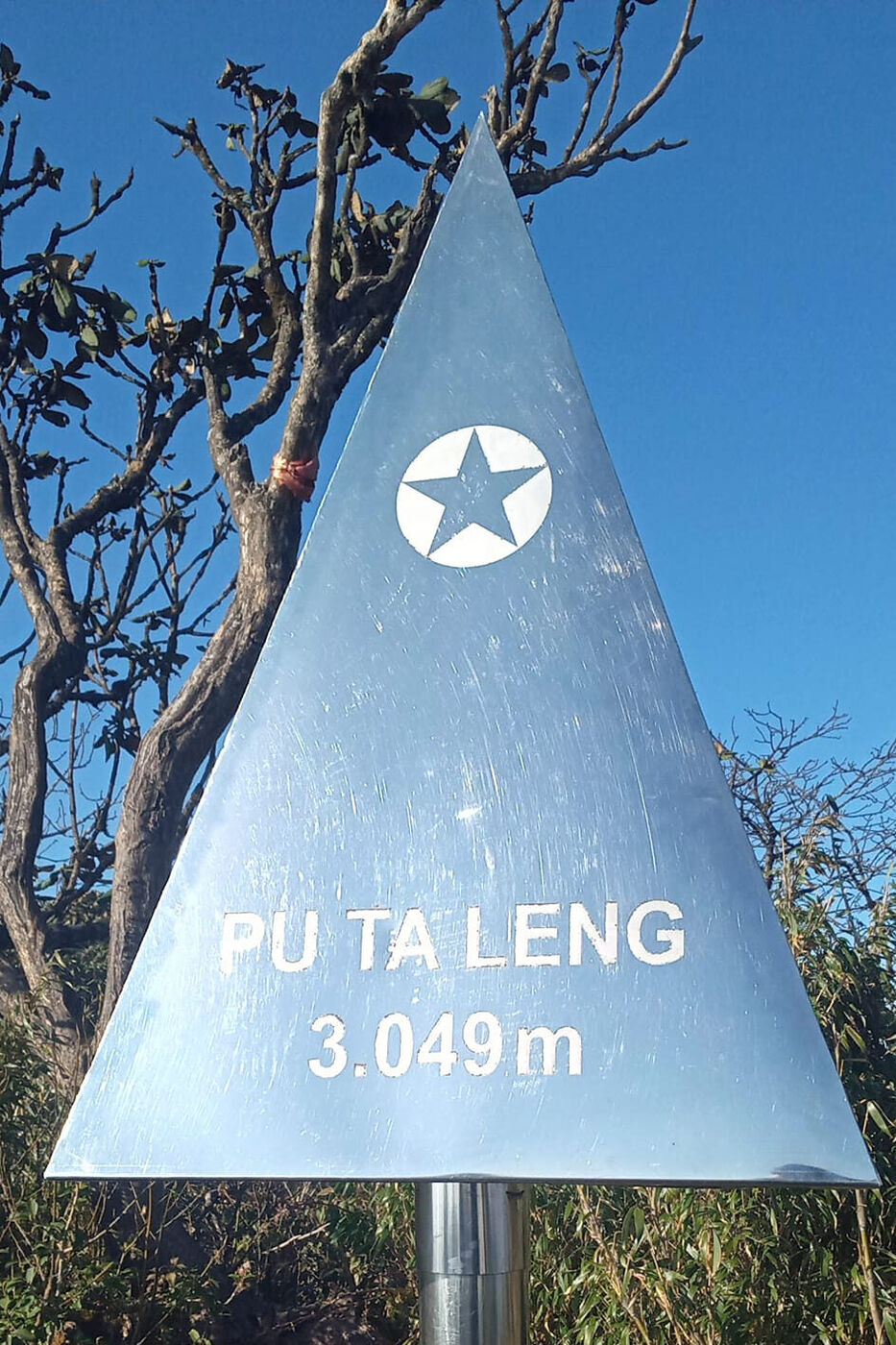
Putaleng peak, 3,049 m high, belongs to the Hoàng Liên Sơn range, located in Tam Đường district — Vietnam's second highest after Fansipan (3,143 m). Unlike Fansipan, which has a cable car, Putaleng can only be conquered by trekking — 3 days 2 nights through primeval forest with moss, dwarf bamboo, and especially hundreds of years old ancient rhododendron forests (Rhododendron) — blooming vibrant red in March – April. The journey is many times more difficult than Fansipan: there are no clear trails, requiring crawling through dense forest, climbing cliffs, and crossing streams. From Putaleng peak, one can see the Hoàng Liên Sơn range and Fansipan — the most magnificent view in the Northwest. The trek starts from Hồ Thầu village (Ô Quý Hồ pass) or Phìn Hồ village. Local porters and trekking experience are required.
Things to do: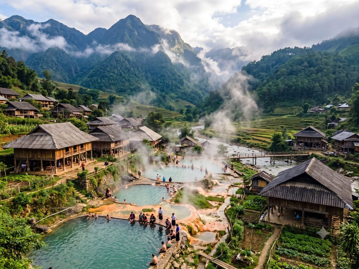
Vàng Pheo hot spring is located in Vàng Pheo commune, Phong Thổ district, 50 km from Lai Châu city. The hot spring gushes from underground at a temperature of 40 – 60°C, flowing as a stream through primeval forest. The area has many natural bathing pools — mineral water rich in sulfur, good for skin and joints. Visitors can bathe for free in the wild natural setting — surrounded by limestone mountains and old-growth forest. Nearby is the Vàng Pheo Red Dao village — home to the traditional Dao herbal bath. From the hot spring, one can continue 40 km to Ma Lù Thàng border gate — an international border gate to Jinping (Yunnan, China).
Things to do: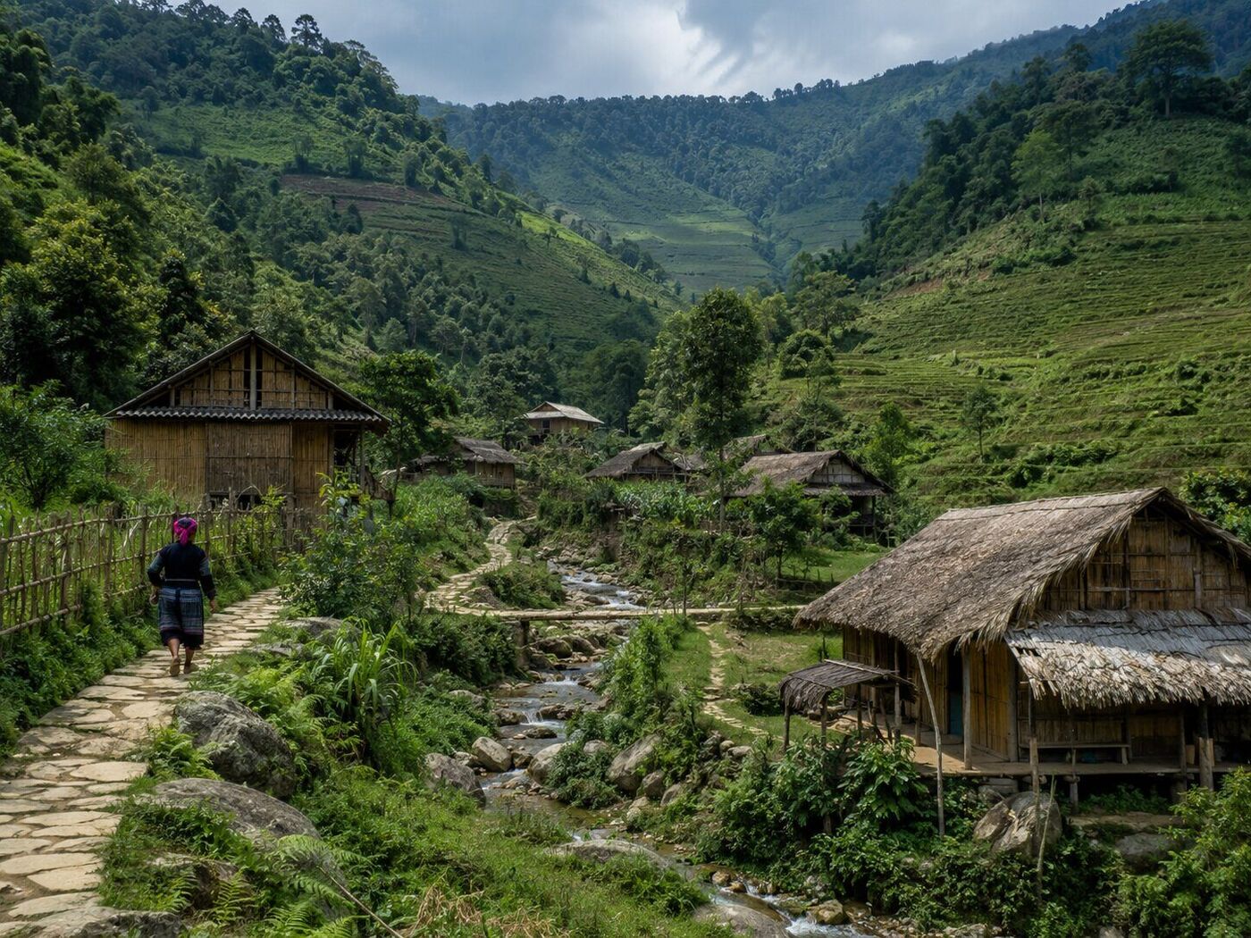
Hồn village and Tả Lèng valley are located in Tam Đường district, 20 km from Lai Châu city. This is a lush green valley by the stream with layered terraced rice fields, villages of the Lự people (one of the smallest ethnic groups in Vietnam, about 5,600 people) and Thái people. Hồn village has a vast rice field in a basin surrounded by mountains — golden rice in September – October, beautiful as a watercolour painting. Tả Lèng valley is above — famous for its view of clouds drifting at ground level in the early morning. Visitors can cycle or ride motorbikes along the valley, visit Lự homestays, eat white rice with stream fish and shrimp paste, and learn about the culture of the Lự people — an ethnic group that still preserves the craft of weaving linen brocade and the custom of blackening teeth.
Things to do:
Mường Tè is the furthest border district in Lai Châu province, 200 km northwest of Lai Châu city — bordering China and Laos. In Sín Thầu commune, there is the A Pa Chải marker (milestone 0) — the westernmost point on mainland Vietnam, where the borders of three countries Vietnam – Laos – China meet, known as 'where the rooster's crow is heard by three countries'. Mường Tè has one of the largest areas in Vietnam but a sparse population — it is home to the Si La ethnic group (only about 900 people in Vietnam) and Mảng (about 4,500 people). The journey to A Pa Chải is a real adventure: border trails through old-growth forests, large streams, requiring a border permit. Mường Tè also has the Lai Châu hydropower reservoir — the largest artificial lake in the Northwest.
Things to do:No. Lai Châu will retain its administrative boundaries according to Resolution 202/2025/QH15.
450 km — about 8 – 9 hours by car via National Route 32 (Hanoi – Mù Cang Chải – Than Uyên – Tam Đường – Lai Châu). There is no airport. You can go to Lào Cai (4h30 by expressway) then to Lai Châu (100 km, 2h30).
Much harder. Putaleng has no cable car, no clear trail — you have to trek through dense jungle for 3 days and 2 nights. It is only for experienced trekkers and requires local porters.
It connects Lai Châu city (via Tam Đường) with Sa Pa (Lào Cai). The pass summit is 2,073 m, and it is 50 km long. It is one of the four great mountain passes of the Northwest (along with Khau Phạ, Pha Đin, Mã Pí Lèng).
It is the westernmost point of Vietnam, Sín Thầu commune, Mường Tè district — the tri-border intersection of Vietnam – Laos – China. It is 200 km from Lai Châu city, 6 – 8 hours by car on mountain roads. A border permit is required, and it is only for backpackers.
There are 20 ethnic groups, notably: Si La (about 900 people — the fewest in Vietnam), Mảng (4,500 people), Lự (5,600 people), Hà Nhì, Cống — extremely rare ethnic groups found only in Lai Châu.