Cao Bằng Province
Non nước Cao Bằng — Bản Giốc waterfall and Global Geopark
Northern Region · Northeast
Non nước Cao Bằng — Bản Giốc waterfall and Global Geopark
Northern Region · Northeast
Cao Bằng province will retain its boundaries after the 2025 merger, not merging with any other province according to Resolution 202/2025/QH15. With an area of 6,700.39 km² and a population of 573,119 people, this is a northeastern border region adjacent to China, notable for Thác Bản Giốc — Southeast Asia's most beautiful natural waterfall — and Non Nước Cao Bằng Global Geopark, recognized by UNESCO in 2018. Cao Bằng is also a cradle of revolution with the Pác Bó historical site — where President Hồ Chí Minh returned after more than 30 years abroad and led the revolution from 1941. Over 8 ethnic groups — mainly Tày, Nùng, Mông, Dao — have left unique cultural identities: Khuổi Ky ancient stone village, highland markets, and the famous Trùng Khánh chestnuts.
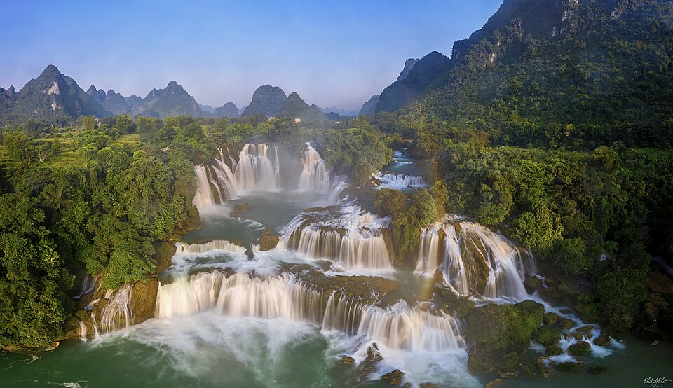
Thác Bản Giốc is located in Đàm Thuỷ commune, former Trùng Khánh region, on the Quây Sơn River flowing along the Vietnam-China border. The waterfall is about 60 m high with the longest slope of 30 m, divided into many limestone tiers spanning hundreds of meters — it is considered the most beautiful natural waterfall in Southeast Asia and one of the most beautiful waterfalls in the world located on a national border. In autumn (September–October), the Quây Sơn River water is emerald green, with white foam — the time when the waterfall is most beautiful in the year. On both sides of the waterfall are forests and interspersed limestone mountains, creating a majestic, pristine landscape.
Things to do: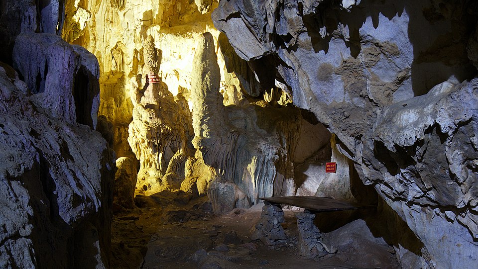
The Pác Bó historical relic site, located in Trường Hà commune, former Hà Quảng region, is where President Hồ Chí Minh lived and worked after returning to Vietnam from abroad on January 28, 1941, after more than 30 years of wandering. Here, he stayed in Cốc Bó cave, worked by the Lê-nin stream and Các Mác mountain — place names he gave associated with revolutionary ideals. The scenery remains very pristine: clear blue stream water flowing through limestone mountains, and bamboo forests green all year round. This is one of the most important historical pilgrimage sites in Cao Bằng.
Things to do: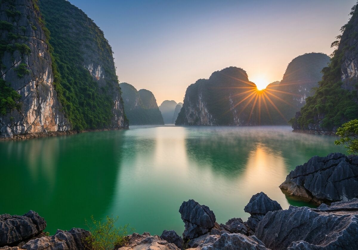
Thang Hen Lake is located within the Non Nuoc Cao Bang UNESCO Global Geopark — a complex of 36 natural freshwater lakes interconnected underground through a system of karst caves. The main lake is spindle-shaped, about 1,000 m long and 100–300 m wide, with deep blue water reflecting the sheer limestone cliffs. Each lake in the complex has its own legend in Tay and Nung culture. This area was recognized by UNESCO in 2018 as a Global Geopark — Vietnam's second such title after Dong Van Karst Plateau — a harmonious blend of geological, ecological, and cultural space.
Things to do: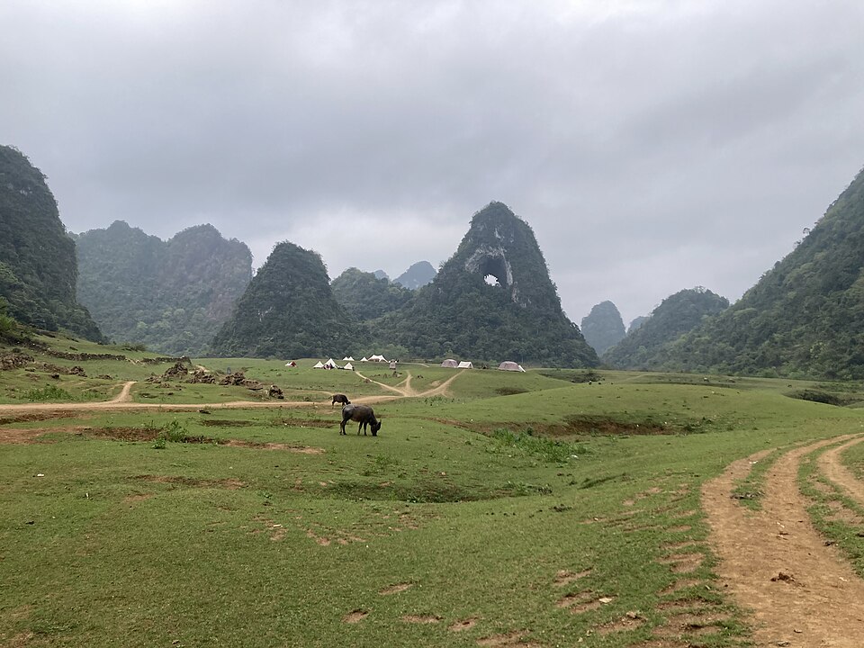
God's Eye Mountain — the Tày people call it 'Phja Piót,' meaning 'mountain with a hole' — is a unique mountain with a cave running through its peak, forming the shape of a giant eye in the sky. Located within the Thang Hen lake complex of the Cao Bằng UNESCO Global Geopark, God's Eye Mountain stands in the middle of a vast meadow. In the dry season, buffalo herders graze livestock at the foot of the mountain; in the rainy season, the meadow floods, forming a natural lake. This is one of Cao Bằng's most unique photo spots — nowhere else has a similar landscape.
Things to do: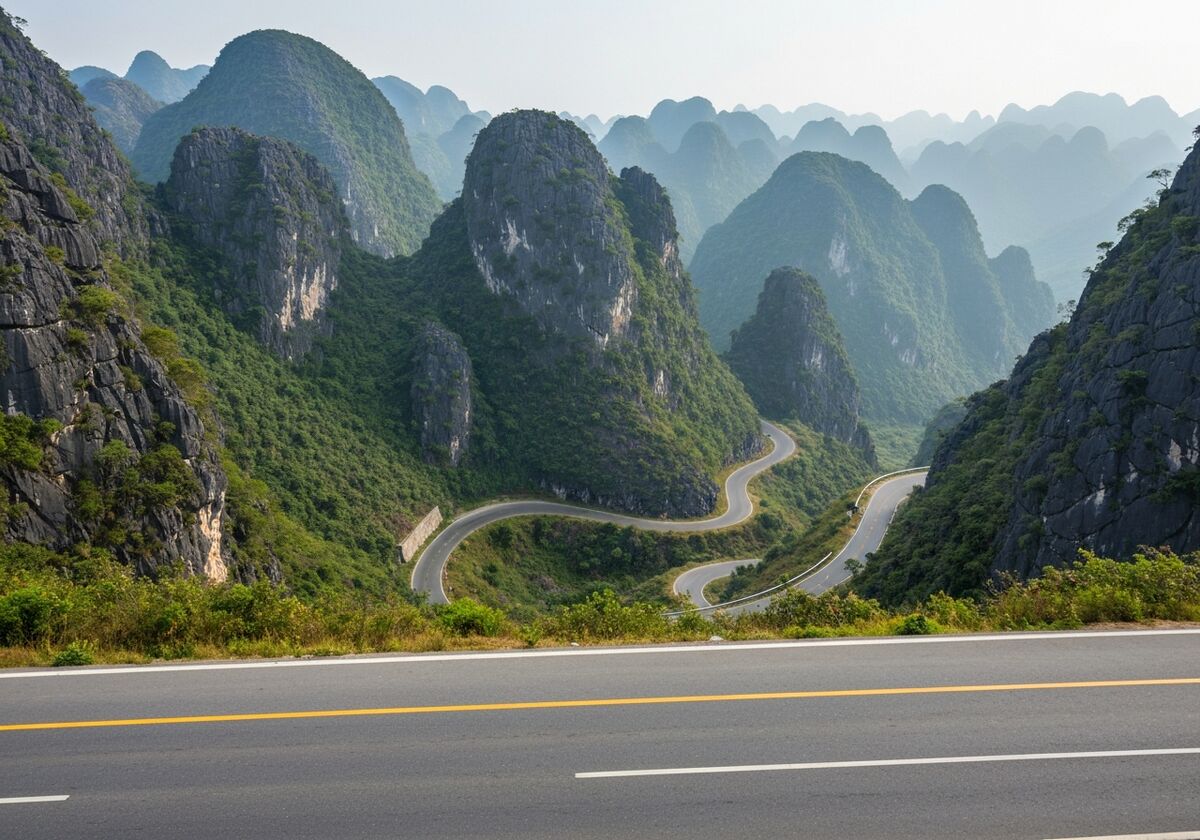
Mã Phục Pass is the highest and most beautiful pass on National Highway 3, leading from Cao Bằng city to the border region of Trùng Khánh. The name 'Mã Phục' means 'kneeling horse' — originating from two rock formations on either side of the pass resembling two kneeling horses. The pass is approximately 700 m high, consisting of 7 winding slopes. From the top of the pass, one can see a panoramic view of the lush green Quảng Uyên valley; during the ripe rice season, it glows golden under the sun, creating a picturesque scene. Mã Phục Pass is often a familiar stop on the 'Pác Bó – Bản Giốc' route for trekkers and tour groups.
Things to do: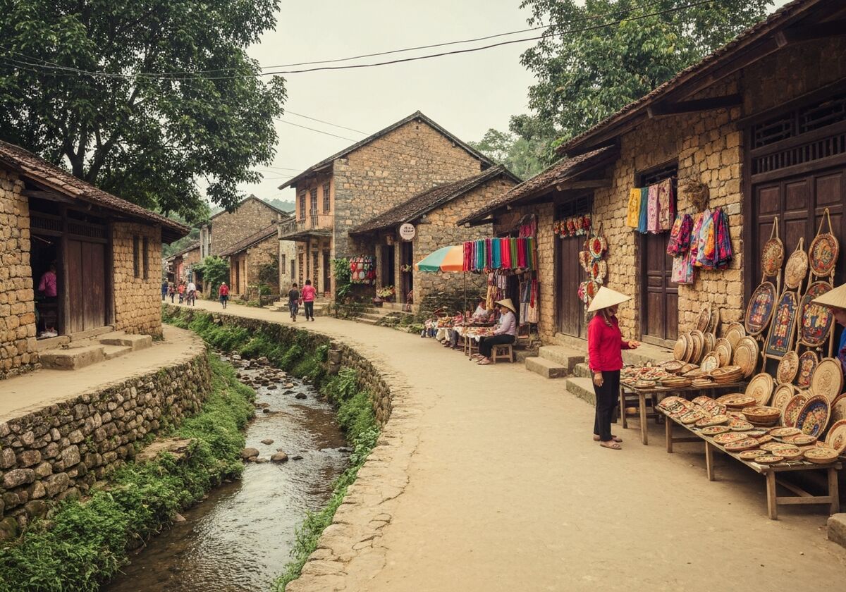
Khuổi Ky Stone Village, located in Đàm Thuỷ commune, the former Trùng Khánh area — very close to Thác Bản Giốc — is an ancient village of the Tày people with about 14 stilt houses made entirely of stone. The stones are skillfully stacked without mortar, the roofs are covered with yin-yang tiles, and many houses are over 400 years old. Khuổi Ky is one of the rare intact stone villages in Vietnam, a testament to the unique construction techniques of the Tày people in the border region. The village has now developed community-based tourism with stone homestays — visitors can sleep overnight in ancient stone houses and enjoy Tày cuisine.
Things to do:Cao Bằng province retains its original boundaries and does not merge with any other province. Area 6,700.39 km², population 573,119 people, administrative center in Cao Bằng city.
Via National Route 3 or Hà Nội – Thái Nguyên expressway then continue on QL3, total distance ~280–370 km, travel time 6–8 hours by car.
Ideally 3 days 2 nights: Day 1 Pác Bó, Day 2 Bản Giốc and Khuổi Ky, Day 3 Thang Hen and Mắt Thần then return.
Vehicle plate prefix 11, area code 0206. Documents issued before the merger remain valid.
September–November: Bản Giốc waterfall is full, the weather is cool, and leaves change color. December–February: cold with light rain; occasionally there is frost on high peaks.
Cao Bằng is famous for Bản Giốc Waterfall, Pác Bó historical site, and Non Nước Cao Bằng Geopark. Hà Giang (former) (now part of Tuyên Quang) is known for Đồng Văn Karst Plateau and Mã Pí Lèng Pass. The two regions can be combined in a 5–7 day trip.