Lâm Đồng Province
Vietnam's largest province — dreamy Đà Lạt and Mũi Né beach
Tây Nguyên · South Central Coast
Vietnam's largest province — dreamy Đà Lạt and Mũi Né beach
Tây Nguyên · South Central Coast
Lâm Đồng was newly established under Resolution 202/2025/QH15, based on the merger of the three former provinces of Lâm Đồng, Đắk Nông, and Bình Thuận. With an area of 24,233.07 km², it is the largest province in Vietnam by area after the merger, surpassing Nghệ An (16,493 km²). The population is approximately 3.87 million people, distributed across three completely distinct geographical regions: the cool year-round Đà Lạt – Bảo Lộc plateau (1,500 m), the pristine Đắk Nông – M'nông plateau with Tà Đùng lake, dubbed the 'Hạ Long of the Central Highlands', and 192 km of Bình Thuận coastline with Mũi Né, Phan Thiết, and Lagi. The administrative center is located in Đà Lạt city — a type I urban area, known as the 'city of a thousand flowers', 1,500 km from Hà Nội and 300 km from TP.HCM.
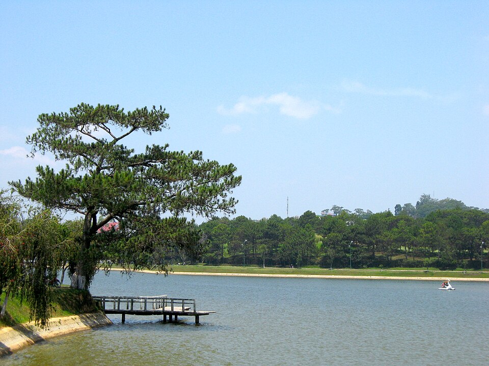
Hồ Xuân Hương is located right in the center of Đà Lạt city. It is an artificial lake created in 1919 when the French built a dam to block the Cam Ly stream. The lake has a circumference of about 5 km, a surface area of 25 ha, and is crescent-shaped, surrounded by pine hills and ancient French architectural structures. This is a symbol of Đà Lạt — visitors can walk a loop around the lake (takes 1h30), ride a tandem bicycle, or pedal a swan boat on the lake. Next to the lake are Đà Lạt market and Lâm Viên Square with two giant artichoke flower and flower bud symbols. Many large hotels such as Du Parc, Dalat Palace, and La Sapinette are concentrated around the lake. Early mornings and late afternoons are when the lake is most beautiful, with thin mist covering the water.
Things to do: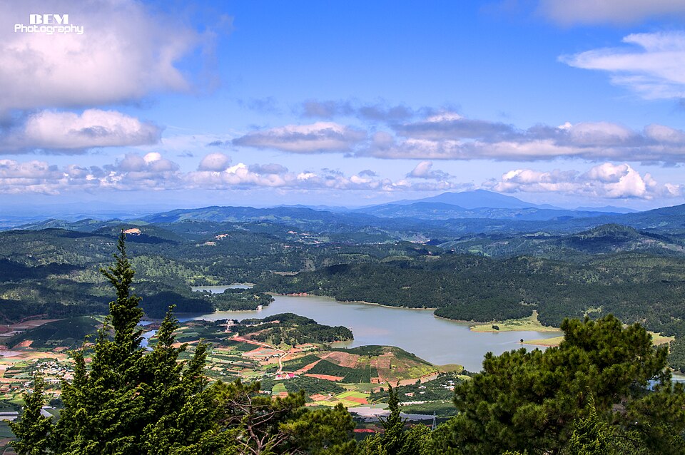
Langbiang Mountain (also known as Langbian Mountain or Twin Mountain) is about 12 km north of Da Lat city center, in Lát commune, Lạc Dương district. The mountain has two peaks: Bà peak (2,167 m) and Ông peak (2,124 m), associated with the love legend of K'Lang (Lạch people) and H'Biang (Chil people) — separated by tribal customs. This is the core area of the Langbiang World Biosphere Reserve recognized by UNESCO in 2015. Visitors can conquer Bà Peak (Radar) by jeep from the foot of the mountain (15 minutes) or by trekking for 3 – 4 hours; from the peak, enjoy panoramic views of Da Lat and the Đan Kia – Suối Vàng grasslands. The K'ho village at the foot of the mountain organizes gong performances and rượu cần in the evening.
Things to do: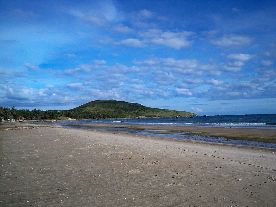
Mũi Né is located about 24 km northeast of Phan Thiết city center, and is the most famous coastal area of former Bình Thuận (now part of Lâm Đồng). The beach stretches over 15 km from Hàm Tiến through Mũi Né to Hòn Rơm, featuring a unique ecosystem: on one side, calm blue sea, on the other, the red sand dunes of Mũi Né and the white sand dunes of Bàu Trắng — like a miniature desert in the tropics. This area is dubbed Vietnam's 'resort capital' with over 100 4-5 star resorts such as Anantara, Pandanus, The Cliff, Aroma, continuously lining Nguyễn Đình Chiểu street. Mũi Né is also a top kitesurfing spot in Southeast Asia — strong northeast winds from November to March attract international competitions.
Things to do: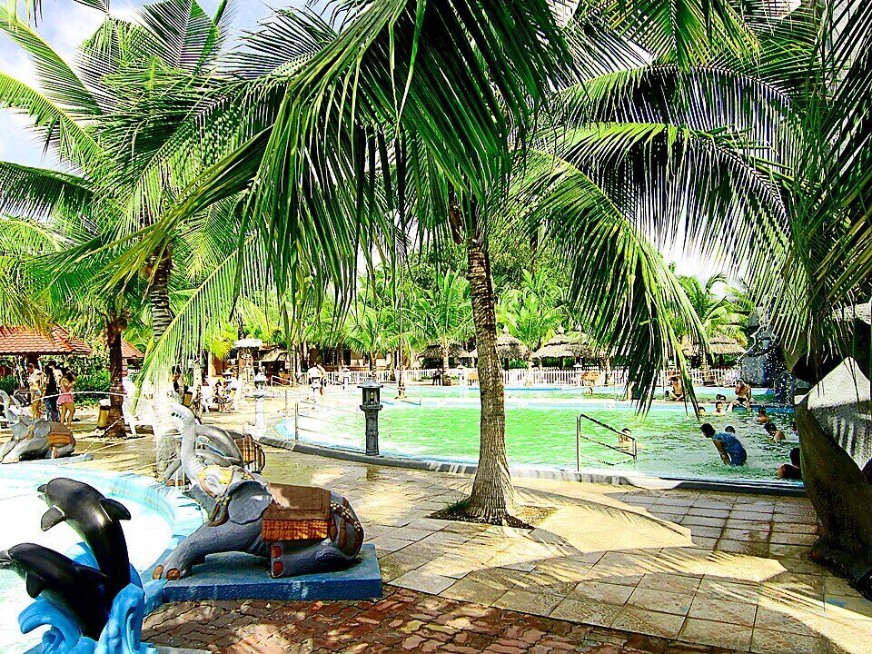
Bình Châu Hot Spring Tourist Area, located in Bình Châu commune, Xuyên Mộc district — the former Bà Rịa – Vũng Tàu region, now assigned to Lâm Đồng due to boundary adjustments after mergers. The area spans over 70 ha, surrounded by primeval forest, with more than 70 natural hot mineral water噴points with temperatures ranging from 37°C to 82°C — visitors can boil eggs at the 'egg lake' right on the ground. The mineral water is rich in sodium, calcium, and magnesium, and has been studied for its therapeutic effects on musculoskeletal and dermatological diseases. The resort features a system of tiered temperature pools, mineral mud bath services, mineral foot soaks with fish nibbling, and a large mineral swimming pool. The 4-star Saigon-Binhchau Eco-resort is one of the largest wellness resorts in Southeast Asia.
Things to do: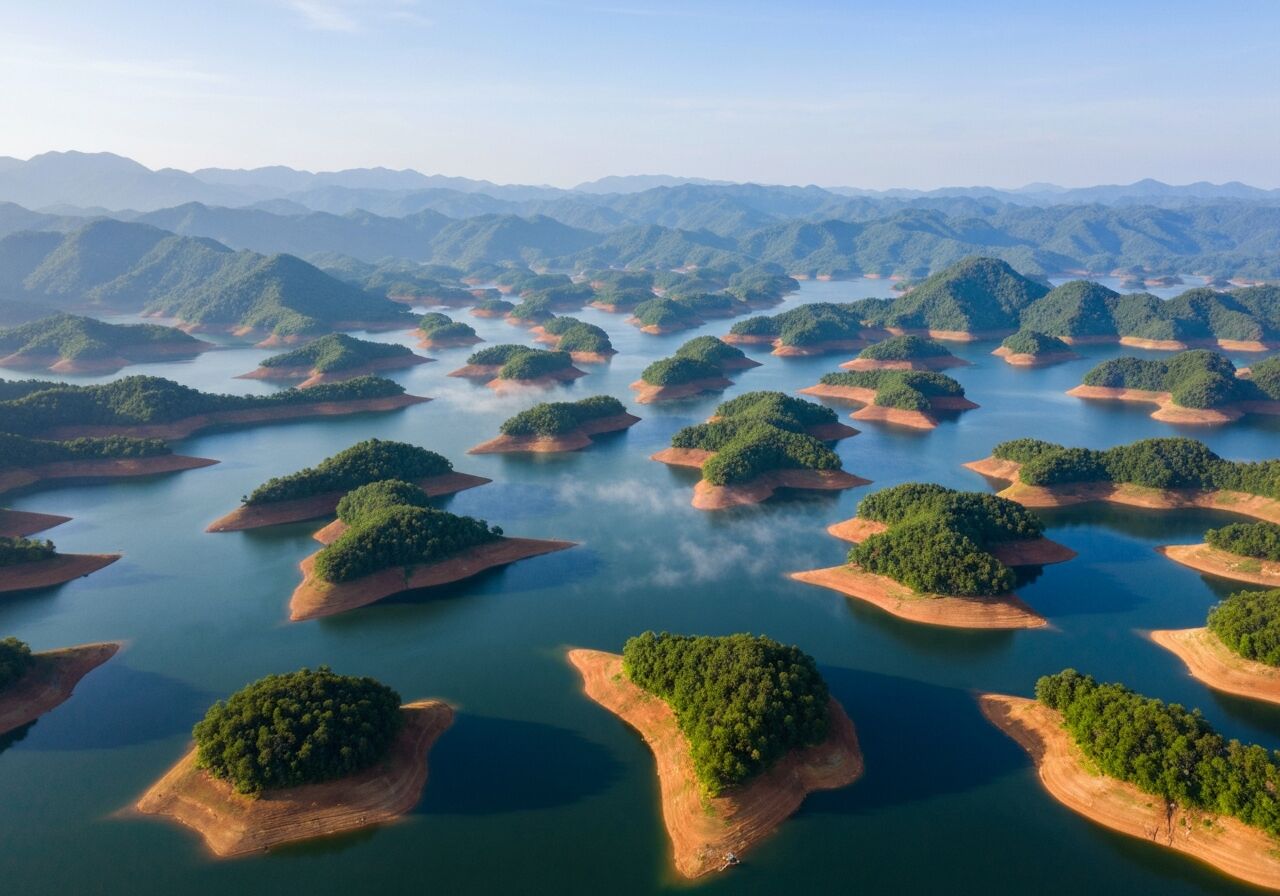
Tà Đùng Lake is located in Đắk Som commune, Đắk Glong district, in the former Đắk Nông area (now Lâm Đồng). This is the Đồng Nai 3 hydroelectric lake with a water surface area of approximately 5,000 ha (rainy season) and 36 scattered large and small islands like an archipelago in the highlands — hence it is dubbed 'the Hạ Long Bay of the Central Highlands'. The lake is within the Tà Đùng Nature Reserve, covering 22,103 ha with primeval forest, home to the rare black-shanked douc langur. The most beautiful view is from a high vantage point on National Road 28 looking down — morning mist covering the lake creates a surreal effect. Visitors can take a boat through the islands, camp on the large island, fish, or trek in the reserve.
Things to do: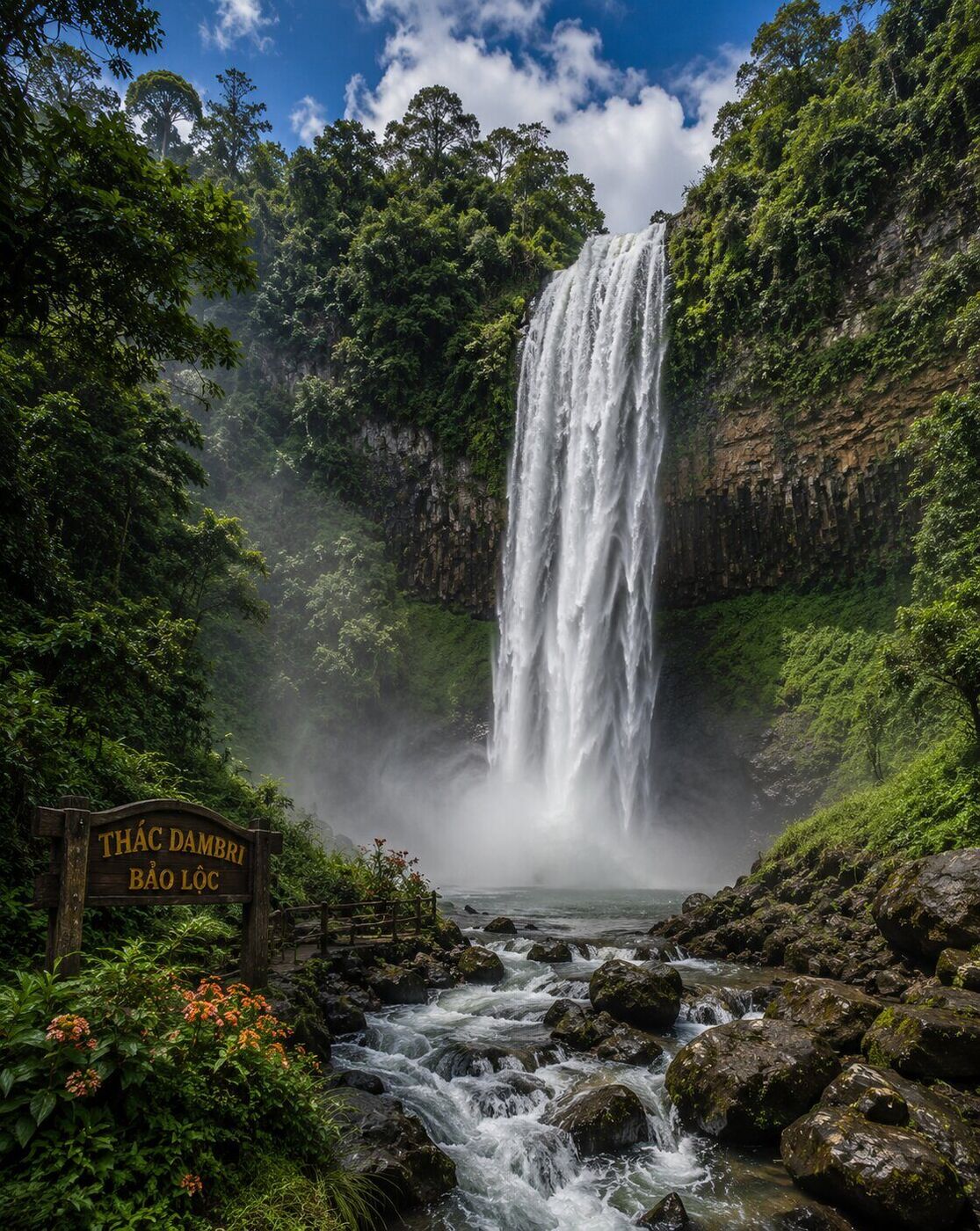
Thác Dambri is located in Đam Bri commune, Bảo Lộc city, about 18 km from Bảo Lộc city center and 130 km from Da Lat. The waterfall is 60 m high and 30 m wide, making it the highest waterfall in former Lâm Đồng and one of the most majestic waterfalls in the Southern Central Highlands. The name 'Dambri' means 'waiting' in the K'ho language — associated with a sad love story of a young couple separated. The 300 ha Dambri ecological tourist area surrounds the waterfall, featuring a 250 m long cable car system crossing the waterfall from above, a 1,650 m long alpine coaster winding through the forest, a roller coaster, and a system of villas amidst coffee plantations. This is a popular stop on the way from Ho Chi Minh City to Da Lat — combined with visiting the Cầu Đất tea and coffee hills.
Things to do:According to Resolution 202/2025/QH15, the new Lâm Đồng will be merged from three provinces: former Lâm Đồng, Đắk Nông, and Bình Thuận. Effective from 01/7/2025.
Yes. With an area of 24,233.07 km², Lâm Đồng is now the largest province in Vietnam after the merger, surpassing Nghệ An (16,493 km²) and Gia Lai mới (21,576 km²).
In Đà Lạt city — a type I urban area, known as the 'city of a thousand flowers', located on the Lâm Viên plateau at an altitude of 1,500 m.
About 160 km — via National Road 28 over Đại Ninh pass and then National Road 1A, it takes about 4 hours by car. This route is within Lâm Đồng province after the merger.
By plane from Ho Chi Minh City to Liên Khương takes about 50 minutes, then 30 km by car to Đà Lạt. By road, a sleeper bus or private car via National Road 20 takes about 7 – 8 hours (300 km).
November – March is the dry season, clear skies, thick fog in the morning. January – February, cherry blossoms and ban flowers bloom. October – November, wild sunflowers glow yellow along the suburban roads.